
-
Phase II drill program progressing ahead of schedule: the first drill hole has been successfully completed, and the program has advanced to Hole 002 of the planned 21-hole, approximately 8,000-metre campaign. A second drill rig is expected to mobilize to site within the coming days. The Company is targeting a first batch of assay results in August 2026.
-
3D magnetic vector inversion identifies three interpreted porphyry-related intrusive centers at depth across the Adelita district: Mezquital, a deep magnetic source beneath Cerro Grande Central, and a newly identified body south of the Cerro Grande skarn – the La Corona target – suggesting a multi-center intrusive system underlies the Adelita district.
-
Cerro Grande skarn corridor resolved into multiple discrete, stacked magnetic bodies: UAV survey delivers approximately 7x improvement in spatial resolution over the previous airborne dataset, resolving the corridor into a series of stacked magnetic highs, consistent with additional skarn potential along strike that remains entirely undrilled beyond the known discovery.
-
Mezquital porphyry target precisely defined: the dipolar anomaly is now constrained at approximately 2.2 kilometres by 700 metres with a peak amplitude of approximately 2,100 nT and an interpreted vertical extent of approximately 750 metres, consistent with a substantial near-surface magnetite-bearing intrusive body.
-
Structural targeting model validated property-wide: Four structural families, confirming the NW-SE × N-S structural intersection as the primary control on the Cerro Grande discovery and identifying multiple new untested structural intersections across the 5,895-hectare property.
VANCOUVER, BC / ACCESS Newswire / July 8, 2026 / Algo Grande Copper Corp. (“Algo Grande” or the “Company“) (TSXV:ALGR)(OTC PINK:ALGRF)(FRA:KM00) announces results from the completed interpretation and 3D magnetic vector inversion (MVI) of its high-resolution UAV magnetic survey at the 100%-owned Adelita Project, Sonora, Mexico. The survey comprised approximately 1,200 line-kilometres of magnetic data acquired in two phases during March and May 2026 by GSM Geoscience. The completed interpretation confirms the structural controls underpinning the Company’s ongoing Phase II drill program and, through 3D magnetic vector inversion, identifies three interpreted porphyry-related intrusive centers at depth across the Adelita district.
The Company also reports that the Phase II diamond drill program is progressing ahead of schedule. The first drill hole has been successfully completed, and the program has advanced to Hole 002 of the planned 21-hole, approximately 8,000-metre campaign across the Cerro Grande skarn expansion, Cerro Potrero South maiden program, and Las Trancas maiden program. A second drill rig is expected to mobilize to site within the coming days, which the Company expects will expedite completion of the program. The Company is targeting a first batch of assay results in August 2026.
Enrico Gay, CEO of Algo Grande Copper Corp., commented: “The detailed magnetics have identified multiple intrusive centers at depth across a 6.5-kilometre corridor, each one a potential engine driving the copper-silver-gold mineralization we see at surface. At Cerro Grande we have a high-grade skarn above a deep porphyry source. At La Corona, a newly identified intrusion with coincident copper anomalism that has never seen a drill bit. At Mezquital, the largest magnetic body on the property with a molybdenum signature pointing to porphyry mineralization at depth. Phase II drilling is now advancing along a 2.5-kilometre prospective corridor at Cerro Grande, with a second rig mobilizing and first assay results expected in August.”
Phase II Drill Program Update
The Phase II diamond drill program, being completed by Major Drilling Group International Inc., commenced in June 2026. The first drill hole has been successfully completed, and the program has now advanced to Hole 002. The program is designed to test 15 expansion holes at the Cerro Grande skarn over approximately 7,200 metres, three maiden holes at Cerro Potrero South over approximately 300 metres, and three maiden holes at the Las Trancas epithermal target over approximately 600 metres, for a total of approximately 8,000 metres across 21 holes. A second drill rig is expected to mobilize to site within the coming days, which the Company expects will expedite completion of the program. The Company is targeting a first batch of assay results in August 2026.
Resolution Improvement and Structural Validation
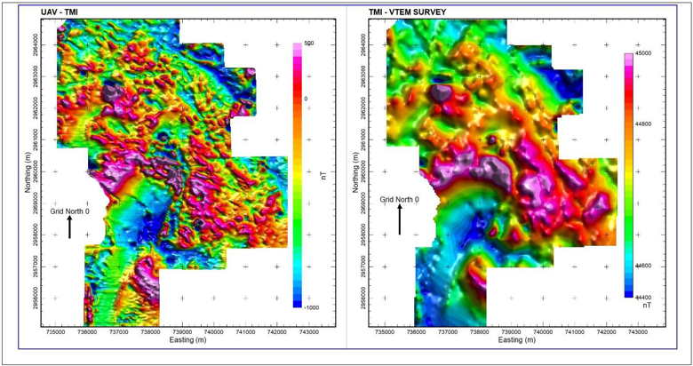
The UAV survey was flown at a nominal altitude of approximately 20 metres above ground with traverse line spacing of 25 metres over the Cerro Grande targets and 50 metres over Mezquital, Cerro Potrero, and Cerro Potrero South, resolving magnetic features at a spatial wavelength of approximately 10 metres. This represents an approximately 7-fold improvement in spatial resolution over the Company’s previous helicopter-borne VTEM survey, which resolved features at approximately 70 metres (Figure 1). As a result, the NW-SE-trending magnetic corridor hosting the Cerro Grande skarn system is now resolved as a series of discrete, elongate magnetic highs rather than a single broad anomaly, consistent with multiple stacked skarn bodies along strike. Other than the previously drill-tested Cerro Grande discovery, none of these newly resolved magnetic bodies has been drill-tested.
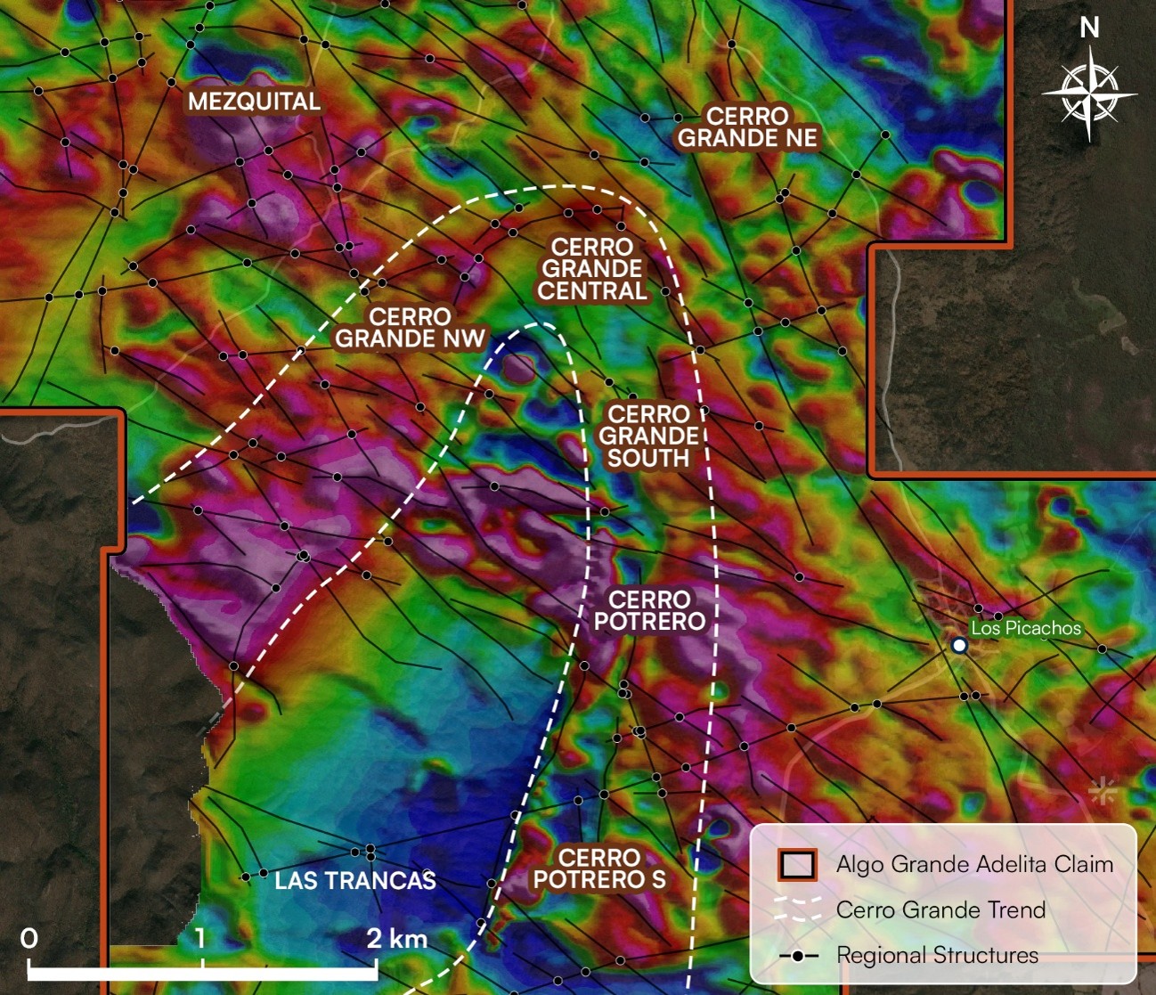
Structural analysis of the magnetic dataset identified 1,277 lineament segments across four structural families: NW-SE, interpreted as the primary Laramide magmatic and hydrothermal corridor controlling porphyry emplacement and skarn mineralisation; E-W, associated with the Las Trancas workings and late-stage epithermal targets; NE-SW, representing subordinate Laramide conduits and porphyry dike controls; and N-S Basin and Range extensional faults, controlling late-stage feeders and low-sulphidation epithermal systems. The Cerro Grande mineralized zone is spatially coincident with the intersection of the dominant NW-SE corridor and a N-S structure, confirming the structural trap model and providing a validated, repeatable targeting criterion across the property (Figure 2). Systematic application of this criterion identified multiple additional untested structural intersection nodes across the 5,895-hectare property.
3D Magnetic Vector Inversion: Multiple Interpreted Porphyry Centers at Depth
A 3D magnetic vector inversion (MVI) was performed using Seequent’s VOXI Earth Modelling platform on a 20-metre octree mesh. The inversion incorporated 87,676 data stations across the full survey area and converged to a normalised root-mean-square (nRMS) data misfit of approximately 1.0 after 13 iterations, consistent with the estimated 8 nT noise floor of the dataset. Residual anomaly amplitudes following inversion were predominantly within ±0.53 nT, confirming that the recovered model adequately explains the observed magnetic field within estimated data uncertainty. The mesh extended to an elevation of −1,800 metres below sea level. MVI, which independently models the full magnetization vector rather than assuming purely induced magnetization, was selected because of the expected remanent magnetization contributions from hydrothermal magnetite, pyrrhotite, and skarn mineralogy within the porphyry-skarn environment.
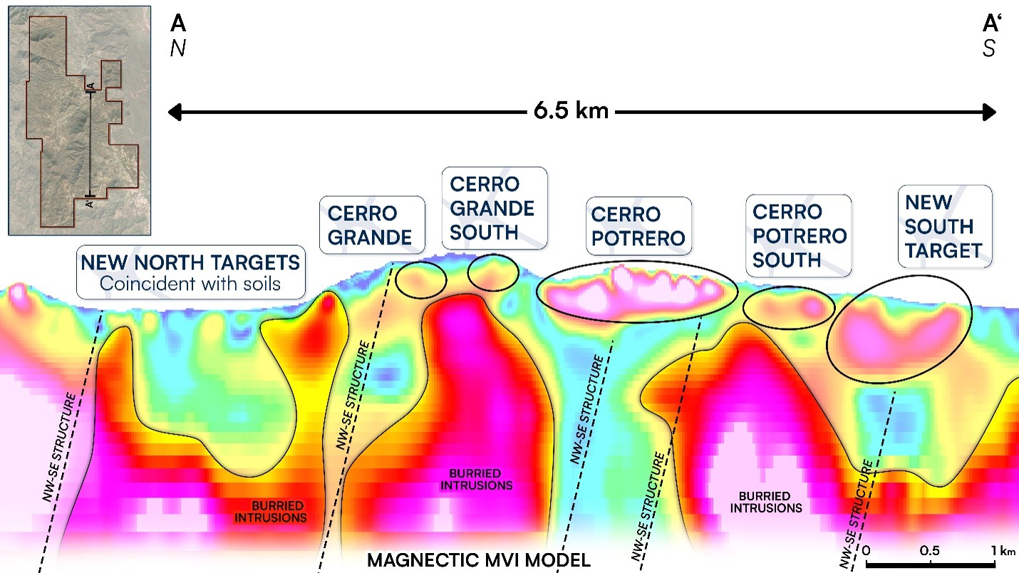
The MVI results identify three interpreted porphyry-related intrusive centers at depth across the Adelita district, as shown in the depth cross-section in Figure 3.
Mezquital
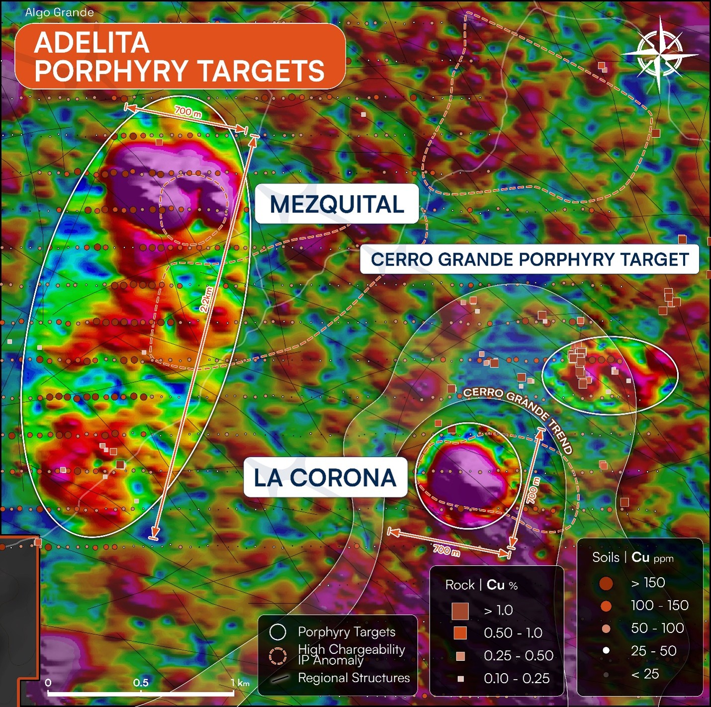
The Mezquital anomaly, the largest and most intensely magnetic feature in the dataset, presents a dipolar footprint of approximately 2.2 kilometres by 700 metres with a peak amplitude of approximately 2,100 nT. The interpreted source body is constrained to approximately 700 by 400 metres, and an interpreted vertical extent of approximately 750 metres, with an adjacent deeper magnetic source also identified in the inversion (Figure 4). The MVI magnetic susceptibility of approximately 0.05 SI is consistent with a substantial magnetite-bearing granodioritic intrusive body. A historical drill hole within the anomaly intercepted magnetite- and hematite-bearing granodiorite with propylitic alteration and an associated molybdenum signature at 50 to 150 metres depth, consistent with a porphyry-proximal intrusive or alteration domain. Mezquital is interpreted as a high-priority porphyry target for a future exploration phase.
Cerro Grande Central
The MVI section beneath the Cerro Grande Central skarn indicates the presence of a broad, high-amplitude magnetic body at depth, interpreted as a possible porphyry-related intrusion and the deeper magmatic source for the hydrothermal system responsible for the surface skarn mineralization (Figure 4). This relationship is consistent with the observation that the highest-grade copper intercepts at Cerro Grande Central occur within zones of lower magnetic susceptibility adjacent to the strongest magnetic body, a pattern typical of magnetite-destructive alteration in copper-rich skarn assemblages. The magnetic anomaly in this context is interpreted as a vector toward the mineralized system rather than a direct representation of the Cu-rich skarn itself. This magnetic body is also coincident with a conductive body in the historical MT sections and a resistivity anomaly at a similar depth, providing independent multi-dataset support for the porphyry interpretation. The convergence of magnetic, MT, and resistivity evidence at this depth supports the porphyry-skarn-CRD continuum model and will be discussed in full in a subsequent release.
La Corona
The MVI model also resolves a third interpreted intrusive center: a broad magnetic body at depth south of Cerro Grande Central, designated the La Corona target (Figure 4). La Corona is identified from geophysical modelling at this stage and has not been drill-tested. At surface, the La Corona area displays copper-anomalous soil samples across three lines at 100-metre spacing and anomalous historic rock samples returning up to 2% Cu, described as skarn-type occurrences. Together with Mezquital and the Cerro Grande Central deep source, La Corona defines a multi-center intrusive framework across the Adelita district. The Company intends to present a full district-scale interpretation of these three centers, including their relationship to a broader porphyry-skarn-carbonate replacement deposit continuum model, in a subsequent release. La Corona is associated with NW-SE structural lineaments consistent with the primary Laramide magmatic-hydrothermal corridor that controls the Cerro Grande discovery.
Geophysical Survey Quality Control
The survey was conducted using SmartMag (5 Hz, Phase 1, March 2026) and MagArrow (1,000 Hz, Phase 2, May 2026) UAV-borne magnetometers on a DJI Matrice 400 platform at a nominal height of approximately 20 metres above ground level. A GEM GSM-19 base station provided continuous diurnal correction data throughout the survey. GPS positions were post-processed using PPK correction, achieving a horizontal positioning accuracy of ≤0.05 metres. Processing included diurnal correction, data cleaning, phase integration, levelling, and generation of enhanced products including TMI, RTP, analytic signal, vertical and horizontal derivatives, tilt derivative, standard deviation, and contact occurrence density.
Qualified Person
The scientific and technical information disclosed in this news release has been reviewed and approved by João Rocha, EurGeol, Vice President of Exploration of Algo Grande Copper Corp., a Qualified Person as defined by National Instrument 43-101. The Qualified Person has reviewed the survey design, data acquisition and processing methodology, and 3D inversion parameters described herein, and considers the resulting geophysical model to be a reasonable and geologically plausible representation of the subsurface magnetic sources at the Adelita Project. Magnetic inversion results are inherently non-unique and have been interpreted in the context of available geological mapping, structural analysis, and surface geochemistry.
About Algo Grande Copper Corp.
Algo Grande Copper Corp. is a growth-focused mineral exploration company advancing the Adelita Project, a district-scale, multi-system copper-silver-gold opportunity positioned in the prolific Arizona-Sonora copper belt.
Algo Grande is dedicated to unlocking the full mineral potential of this under-explored corridor through disciplined data-driven exploration, technical excellence, and a firm commitment to value creation for shareholders. The 5,895-hectare Adelita Project is anchored by the high-grade Cerro Grande Cu-Ag-Au skarn discovery, which exhibits strong continuity along a defined corridor extending over 6 kilometres. Reprocessing of legacy geophysical data and field mapping indicate the presence of a potential porphyry system at depth, suggesting a classic skarn-porphyry mineralization model similar to major deposits found throughout northwestern Mexico.
ON BEHALF OF ALGO GRANDE COPPER CORP.
Enrico Gay
Chief Executive Officer
For more information, please contact:
E-mail: info@algo-grande.com
Website: www.algo-grande.com
NEITHER THE TSX VENTURE EXCHANGE NOR ITS REGULATION SERVICES PROVIDER (AS THAT TERM IS DEFINED IN THE POLICIES OF THE TSX VENTURE EXCHANGE) ACCEPTS RESPONSIBILITY FOR THE ADEQUACY OR ACCURACY OF THIS RELEASE.
Cautionary Statement on Forward-Looking Information
This news release contains statements and information that, to the extent that they are not historical fact, constitute “forward-looking information” within the meaning of applicable securities legislation. Forward-looking information is based on the reasonable assumptions, estimates, analysis and opinions of management made in light of its experience and its perception of trends, current conditions and expected developments, as well as other factors that management believes to be relevant and reasonable in the circumstances at the date that such statements are made, but which may prove to be incorrect. Forward-looking information involves known and unknown risks, uncertainties and other factors that may cause the actual results, performance or achievements of Algo Grande to differ materially from any future results, performance or achievements expressed or implied by the forward-looking information, including, but not limited to, statements relating to the Company’s planned Phase II drilling program, results of drilling, and those listed in filings made by Algo Grande with the Canadian securities regulatory authorities (which may be viewed at www.sedarplus.ca). Accordingly, readers should not place undue reliance on any such forward-looking information. Further, any forward-looking statement speaks only as of the date on which such statement is made. New factors emerge from time to time, and it is not possible for Algo Grande’s management to predict all of such factors and to assess in advance the impact of each such factor on Algo Grande’s business or the extent to which any factor, or combination of factors, may cause actual results to differ materially from those contained in any forward-looking statements. Algo Grande does not undertake any obligation to update any forward-looking information to reflect information, events, results, circumstances or otherwise after the date hereof or to reflect the occurrence of unanticipated events, except as required by law including securities laws.
Rock and soil sampling are selective by their nature. Results of rock and soil sampling programs are not necessarily indicative of mineralization across the property.
SOURCE: Algo Grande Copper Corp.
View the original press release on ACCESS Newswire


